What the reasoning behind that? Too many people? We went up a couple of years ago and they were building the new gift shop. We had to park in a lot, about 3/4s of the way up, and then get bussed up to the peak.They require an advance reservation to go up the road now. . . .
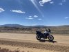
where did you TAKE your Tenere today?
- Thread starter rider33
- Start date
How far in advance do you need to reserve? I assume there is a web site? Several years ago we did the Road to the Sun in Glacier NP. It was first come, first serve, but you better come early at that time. It may be similar to Pikes Peak now.They require an advance reservation to go up the road now.
Besides, we rode up it a couple weeks ago............They stopped us at Devil's Playground due to it snowing at the top.
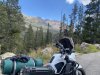
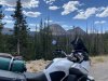
View attachment 94924
View attachment 94925
View attachment 94926
Sent from my SM-N950U using Tapatalk
Attachments
-
 231.7 KB Views: 19
 -
 292.4 KB Views: 18
 -
 146.3 KB Views: 18
Cycledude
Well-Known Member
yes I believe most National parks now require the day pass to drive through, the pass costed $2 per vehicle in 2021 online and they email it to you. But I believe if you enter the park before 9am the extra $2 day pass is not required. Don’t wait until you get to the park to apply for the $2 day pass because the wifi Service is terrible slow there at least it was for us so one of our friends daughter did the rest of the parks for us from her home and emailed them to us.How far in advance do you need to reserve? I assume there is a web site? Several years ago we did the Road to the Sun in Glacier NP. It was first come, first serve, but you better come early at that time. It may be similar to Pikes Peak now.
Sent from my SM-N950U using Tapatalk
Cycledude
Well-Known Member
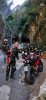
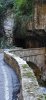
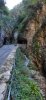
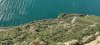
wow those are some very amazing roads !
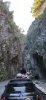
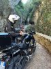
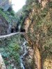
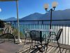
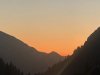
They are above Garda' Lake...wow those are some very amazing roads !
I should have taken more pictures but we were on a hurry to keep going...
Next time I will focus more on that.
There are another couple of roads but you should park the bike and 'trek" a bit...
I will definitely do that next year.
sheikyerbooty
Well-Known Member
wee cruise up the coast with my niece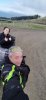
Ss1
Well-Known Member
Where is it in New Zealand?маленький круиз по побережью с моей племянницей
sheikyerbooty
Well-Known Member
Karitane, looking south towards Taiaroa head
First ride in over a month, damn I missed that. Let the bike take me to the range to combine my two hobby’s. Good times
SkunkWorks
Well-Known Member
Yes, they are trying to limit people on the mountain and in the parking-areas during the summer season.What the reasoning behind that? Too many people? We went up a couple of years ago and they were building the new gift shop. We had to park in a lot, about 3/4s of the way up, and then get bussed up to the peak.
Similar to what National-Parks are doing.
SkunkWorks
Well-Known Member
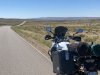
Enjoyed the gorgeous weather yesterday, and took the Tenere for a 200-mile ride to test out the new Suspension.
Am quite pleased!
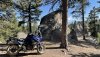
I got stuck on the wrong side of Sedalia when they decided to stop of freight-train across the only road thru town.
Had to back-track a bit down the 105 and come home via Castle-Rock.
Am quite pleased!
I got stuck on the wrong side of Sedalia when they decided to stop of freight-train across the only road thru town.
Had to back-track a bit down the 105 and come home via Castle-Rock.
Wow. Are they new "max capacity" limits, or are there that many more people visiting the park(s)? With the price of gas, I would have expected less people.Yes, they are trying to limit people on the mountain and in the parking-areas during the summer season.
Similar to what National-Parks are doing.
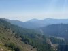
Took a little trip from Boulder to SnowBird Utah to see the kid last week. Went up Poudre Canyon and it was so bloody crowded I could not bare to even stop for a photo. Things let up on the west side near Gould/Walden.
edit:got things backwards maybe as captions are on top of photos
Just outside Coalmont headed for Buffalo pass over to Steamboat. Pass is on the left side of photo
West side of Buffalo looking across Medicine Bow Routt NF.
Camped here at SteamBoat Lake. Beautiful area but a campsite many trailers. Some D-Bag with TN plates running a generator until 10pm limit. Still nice though.
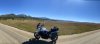
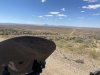
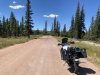
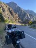
Next 3 images are CR 129 headed for Baggs,WY. This road is excellent surface with relatively high running speed and beatiful scenery with virtually no traffic.
AT Baggs I went south just back inside the Colorado state line and picked up CR 4 headed west into the south edge of the Red Desert. Road is asphalt for a short distance then about 50 miles of dirt in the most magnificently remote desert I have ever seen. No buildings or power lines just gas well installations. I think I saw 2 pickup trucks the entire stretch. This is were I also realized I was inadequately prepared. Wont do a ride like this again unless I have a SPOT type device. Road terminates near Flaming Gorge about 50 miles south of Rock Springs , WY.
After this I was f'n melba toast. Stopped at a park in Rock Springs and just lay under a tree and drank water.
After this headed over to Green River to stay with friends for the night. Will pick up the leg from GR to SnowBird in next post.
edit:got things backwards maybe as captions are on top of photos
Just outside Coalmont headed for Buffalo pass over to Steamboat. Pass is on the left side of photo
West side of Buffalo looking across Medicine Bow Routt NF.
Camped here at SteamBoat Lake. Beautiful area but a campsite many trailers. Some D-Bag with TN plates running a generator until 10pm limit. Still nice though.
Next 3 images are CR 129 headed for Baggs,WY. This road is excellent surface with relatively high running speed and beatiful scenery with virtually no traffic.
AT Baggs I went south just back inside the Colorado state line and picked up CR 4 headed west into the south edge of the Red Desert. Road is asphalt for a short distance then about 50 miles of dirt in the most magnificently remote desert I have ever seen. No buildings or power lines just gas well installations. I think I saw 2 pickup trucks the entire stretch. This is were I also realized I was inadequately prepared. Wont do a ride like this again unless I have a SPOT type device. Road terminates near Flaming Gorge about 50 miles south of Rock Springs , WY.
After this I was f'n melba toast. Stopped at a park in Rock Springs and just lay under a tree and drank water.
After this headed over to Green River to stay with friends for the night. Will pick up the leg from GR to SnowBird in next post.
Last edited:
SkunkWorks
Well-Known Member
Can't really answer that one............ I know they were restricting the number of people entering National Parks during covid.Wow. Are they new "max capacity" limits, or are there that many more people visiting the park(s)? With the price of gas, I would have expected less people.
It looks like they are continuing that trend and will hang onto that one.
Since you have to create an account and pay for your timed entry reservation online ($2), they now know exactly WHO is coming and going.
Same for Pikes Peak Summit entry.
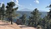
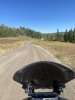
Green River to Snowbird Leg. Had to ride down Hwy 80 for a few miles which sucked. Finally picked up some county roads heading south to Piedmont,WY where I encountered a massive flow of large 5th wheel campers and boats, coming out of Flaming Gorge I expect. Finally got back on dirt when I hit CR 173. This was mostly good surface but did encounter some really loose gravel and when I found out the Tourance tires were not up to this challenge.
173 headed south toward Piedmont in South West WY.
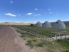
Ghost Town of Piedmont , Wy and the Piedmont Charcoal Kilns. Built circa 1870. Kilns are 30 feet wide and 30 feet tall. Built by a guy who constructed some of the Pony Express sites. Charcoal shipped to SLC to smelter and black smiths.
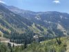
Now headed toward the High Uinta's
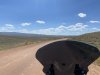
Uinta's are one of the only and the highest mountain range in the USA that run East/West
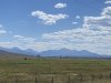
Park City Utah on the other side of these Cones.
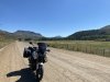
Cruised through Park City , beautiful this time of year. Zipped up over Gaurdsman pass and down pass Solitude and Brighton ski resorts and down Big CottonWood canyon. This is near the bottom , right around the corner from this photo was half dozen cops scraping a sport bike off the road.
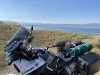
Great fun run up Little Cotton Wood Canyon to Snowbird. The view from my kids little 400 square apartment.
View down Valley toward Sandy.
173 headed south toward Piedmont in South West WY.
Ghost Town of Piedmont , Wy and the Piedmont Charcoal Kilns. Built circa 1870. Kilns are 30 feet wide and 30 feet tall. Built by a guy who constructed some of the Pony Express sites. Charcoal shipped to SLC to smelter and black smiths.
Now headed toward the High Uinta's
Uinta's are one of the only and the highest mountain range in the USA that run East/West
Park City Utah on the other side of these Cones.
Cruised through Park City , beautiful this time of year. Zipped up over Gaurdsman pass and down pass Solitude and Brighton ski resorts and down Big CottonWood canyon. This is near the bottom , right around the corner from this photo was half dozen cops scraping a sport bike off the road.
Great fun run up Little Cotton Wood Canyon to Snowbird. The view from my kids little 400 square apartment.
View down Valley toward Sandy.
Attachments
-
 227.6 KB Views: 5
Stay tuned for the return legsGreen River to Snowbird Leg. Had to ride down Hwy 80 for a few miles which sucked. Finally picked up some county roads heading south to Piedmont,WY where I encountered a massive flow of large 5th wheel campers and boats, coming out of Flaming Gorge I expect. Finally got back on dirt when I hit CR 173. This was mostly good surface but did encounter some really loose gravel and when I found out the Tourance tires were not up to this challenge.
173 headed south toward Piedmont in South West WY.
View attachment 95118
Ghost Town of Piedmont , Wy and the Piedmont Charcoal Kilns. Built circa 1870. Kilns are 30 feet wide and 30 feet tall. Built by a guy who constructed some of the Pony Express sites. Charcoal shipped to SLC to smelter and black smiths.
View attachment 95119
Now headed toward the High Uinta's
View attachment 95120
View attachment 95121
Uinta's are one of the only and the highest mountain range in the USA that run East/West
View attachment 95122
Park City Utah on the other side of these Cones.
View attachment 95123
Cruised through Park City , beautiful this time of year. Zipped up over Gaurdsman pass and down pass Solitude and Brighton ski resorts and down Big CottonWood canyon. This is near the bottom , right around the corner from this photo was half dozen cops scraping a sport bike off the road.
View attachment 95125
Great fun run up Little Cotton Wood Canyon to Snowbird. The view from my kids little 400 square apartment.
View attachment 95126
View down Valley toward Sandy.
View attachment 95127
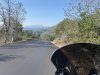
The leg from Snowbird to Meeker
Zip down Little CottonWood and then up Big Cottonwood.
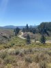
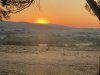
The view from Guardsman pass looking east down at Bonanza Flats. This area was threatened by development and Park City and other conservation organizations raised almost $40 million to purchase it and turn it into a conservation area. Haze from fires.
Grab this little sliver of asphalt called Pine Ridge road just off the summit of Guardsman. Really curvy little road and descends into Midway ,UT. Don't want to run a wheel off here, absolutely no shoulder. Beautiful run down.
Midway then Heber City grabed Hwy40 to Strawberry Reservoir . This res is supposed to have great fishing and set at 7,600 feet elevation. Had the grip heaters running.
On to Vernal and Then skirt the South End of the Dinosaur National Monument. I want to come back and ride into the park sometime.
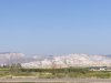
Now back in good old Colorado , near Rangely , I pick up White River. This river is almost 190 miles long. I come in about the half way point and will follow it it about 90 miles almost to its source in the Flat Top Wilderness area.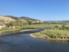
White River Valley near Rangely. Irrigated agriculture in the desert.
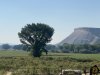
Campsite about 5 miles outside Meeker, Elk hunting country.
Next up: The run along the White River into the Flat Tops and Home.
Zip down Little CottonWood and then up Big Cottonwood.
The view from Guardsman pass looking east down at Bonanza Flats. This area was threatened by development and Park City and other conservation organizations raised almost $40 million to purchase it and turn it into a conservation area. Haze from fires.
Grab this little sliver of asphalt called Pine Ridge road just off the summit of Guardsman. Really curvy little road and descends into Midway ,UT. Don't want to run a wheel off here, absolutely no shoulder. Beautiful run down.
Midway then Heber City grabed Hwy40 to Strawberry Reservoir . This res is supposed to have great fishing and set at 7,600 feet elevation. Had the grip heaters running.
On to Vernal and Then skirt the South End of the Dinosaur National Monument. I want to come back and ride into the park sometime.
Now back in good old Colorado , near Rangely , I pick up White River. This river is almost 190 miles long. I come in about the half way point and will follow it it about 90 miles almost to its source in the Flat Top Wilderness area.
White River Valley near Rangely. Irrigated agriculture in the desert.
Campsite about 5 miles outside Meeker, Elk hunting country.
Next up: The run along the White River into the Flat Tops and Home.
Blind Squirrel
Active Member
I took mine from Lexington SC to Flatwoods WV. Attending the FJR EOM rally.
whisperquiet
Well-Known Member
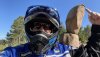
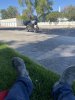
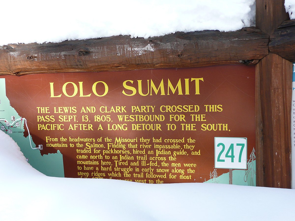
I rode Lolo Pass/Hwy 12 with two friends yesterday. We left St. Louis, MO on Sunday enroute the Pacific NW for a two and half week ride.
Visitor center……
 en.wikipedia.org
Visitor center……
Lolo Pass (Idaho–Montana) - Wikipedia
en.wikipedia.org