I'm assuming that's where their plane crashed.Hmmm....not sure what y'all mean.
Fill me in.
SHUMBA
where did you TAKE your Tenere today?
- Thread starter rider33
- Start date
Kyle_E
Well-Known Member
Hmmm....not sure what y'all mean.
Fill me in.
SHUMBA
Sent from my SM-A715W using Tapatalk

The Day the Music Died - Wikipedia
 en.wikipedia.org
AZMike
Well-Known Member
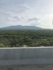
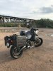
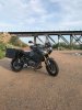
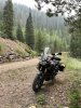
I did a short 85 mile ride this morning to test out a new Sargent seat on the backroads south of Tucson, AZ. We got 7 inches of rain in July and the desert looks like Ireland. I forgot how well the S10 soaks up crappy backroads with ease. Fun little trip but home by 8am because 105 is the high today. (pics are of the Rincon mountains and Davidson Canyon Bridge)
Attachments
-
 88.5 KB Views: 43
 -
 207.6 KB Views: 44
 -
 203.7 KB Views: 43
14kmtnman
Well-Known Member
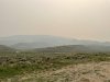
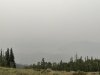
I had a really smoky ride today. It was somewhat smoky when I started but after I came out of the Eisenhower tunnel under the continental divide, heading to Lake Dillon/Silverthorne, it became much worse. As I headed north towards Kremmling the whole valley was socked in. Could barely see the west side mountains. I got to my turn off at Williams Peak rd and headed in.
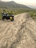
The road heads off towards the little dark peak about a 1/3 of the way from the rh side. The road ends up on the far peak ridge, but dead ends on all of the legs I tried to follow.
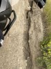
The valley floor, up to about the base of the small peak is all dried out clay. It is also very rutted. I would not want to be there if it was raining. There were lots of skid marks imbedded in the clay from 4x vehicles. As I was negotiating one of those ruts, the front tire did what is was supposed to do, but the back tire decided that it didn't want to go across, but continue on up the rut sideways. All of sudden it grabs traction and the bike does a 90 deg turn towards the edge of the road. As you might know, when these heavy bikes decide go somewhere on their own, it is hard to stop them. Thankfully I was able to keep the bike upright but wound up with the bike going up the embankment. The front tire was at the top, but the rear was now in a little gully and I could not get enough leverage to roll the bike back while seated. I had to get off the bike & kind of lift the rear and push/pull at the same time to get it back on the road. I'm lucky there wasn't one of the below canyons there too.
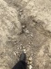
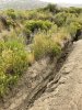
This is looking down where I took the above picture. That is a size 13 boot in the hole, with the depth being about 1 1/2 to 2 ft. There were lots of these all over the road going in different directions and angles, probably because of all the monsoon rains we they have had there. This is not to far away from the east end of the Glenwood canyon that has been shut down because of the landslides.
Here is another one. Some of these gulley's are pushing 3-4 ft deep.
This is looking down from farther up the trail. The road I came in on is just to the right of the frame. You can just make out
the white line of the highway. You can also barely make out GreenMountain reservoir on the lh side. This is the little dark peak that I mention in the first picture. Above here the road turns more rocky, with no clay.
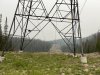
At one point almost at the top, it starts following the power lines for a short distance. This is looking back down the trail.
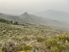
One last shot from the top looking towards GreenMountain reservoir. This would be a beautiful ride on a clear day.
There is a big mountain range behind the reservoir hidden in the smoke.
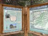
I went back down, back tracked to the Ute pass road & headed over to the Lake Evelyn trailhead thinking the lake would be right there. It wasn't, so no pictures of the lake. Looking at this map, I see that this trailhead was just on the other side of the mountain to the west of where I was early last year on another dead end road.
The road to the lake was pretty decent. It's far enough from any town, that it doesn't appear to get much traffic.
After the Lake Evelyn side trip, I head over to Winter Park via dirt roads for lunch and head home.
The road heads off towards the little dark peak about a 1/3 of the way from the rh side. The road ends up on the far peak ridge, but dead ends on all of the legs I tried to follow.
The valley floor, up to about the base of the small peak is all dried out clay. It is also very rutted. I would not want to be there if it was raining. There were lots of skid marks imbedded in the clay from 4x vehicles. As I was negotiating one of those ruts, the front tire did what is was supposed to do, but the back tire decided that it didn't want to go across, but continue on up the rut sideways. All of sudden it grabs traction and the bike does a 90 deg turn towards the edge of the road. As you might know, when these heavy bikes decide go somewhere on their own, it is hard to stop them. Thankfully I was able to keep the bike upright but wound up with the bike going up the embankment. The front tire was at the top, but the rear was now in a little gully and I could not get enough leverage to roll the bike back while seated. I had to get off the bike & kind of lift the rear and push/pull at the same time to get it back on the road. I'm lucky there wasn't one of the below canyons there too.
This is looking down where I took the above picture. That is a size 13 boot in the hole, with the depth being about 1 1/2 to 2 ft. There were lots of these all over the road going in different directions and angles, probably because of all the monsoon rains we they have had there. This is not to far away from the east end of the Glenwood canyon that has been shut down because of the landslides.
Here is another one. Some of these gulley's are pushing 3-4 ft deep.
This is looking down from farther up the trail. The road I came in on is just to the right of the frame. You can just make out
the white line of the highway. You can also barely make out GreenMountain reservoir on the lh side. This is the little dark peak that I mention in the first picture. Above here the road turns more rocky, with no clay.
At one point almost at the top, it starts following the power lines for a short distance. This is looking back down the trail.
One last shot from the top looking towards GreenMountain reservoir. This would be a beautiful ride on a clear day.
There is a big mountain range behind the reservoir hidden in the smoke.
I went back down, back tracked to the Ute pass road & headed over to the Lake Evelyn trailhead thinking the lake would be right there. It wasn't, so no pictures of the lake. Looking at this map, I see that this trailhead was just on the other side of the mountain to the west of where I was early last year on another dead end road.
The road to the lake was pretty decent. It's far enough from any town, that it doesn't appear to get much traffic.
After the Lake Evelyn side trip, I head over to Winter Park via dirt roads for lunch and head home.
Last edited:
RogerRZ
Well-Known Member
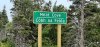
Meat Cove, Nova Scotia. Neighborhood isn't too noisy...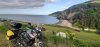
Attachments
-
 192.3 KB Views: 9
RogerRZ
Well-Known Member
That's what it said on the sign. Saw a couple of seals and a whale, but that's about it.Uh. . . . Meat Cove?
Well this afternoon started out with a wash…

Shortly after that we were straightening out my brothers alteider crash bars (the right side was almost touching the plastic when he bought it).

A bit later after helping a friend work on his car. We got realized the is an opportune time for a ride…. I mean that what the bike are begging us for here right?

Alas even with Dad out of town 3 of us did a short loop. I’d throw in a video but….as far as I know this is a pic only platform.


Sent from my iPhone using Tapatalk
Sierra1 is now thinking “good enough for me, I’ll bring the ketchup” .That's what it said on the sign. Saw a couple of seals and a whale, but that's about it.
DamonS
Active Member
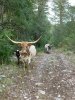
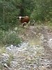
the caption should read: We caught this Super Tenere in the wild and decided to try to tame it.
Haha yupthe caption should read: We caught this Super Tenere in the wild and decided to try to tame it.

Sent from my iPhone using Tapatalk
RogerRZ
Well-Known Member
RogerRZ
Well-Known Member
And as far as where I took the bike today, well first order of business was to snap a pic of the bike on the beautiful beach below. After all, I had been on plenty of beaches before, right? A few things:
1. All beaches aren't created equal.
2. The $#@&**## traction control defaults to nanny mode.
3. A worn Shinko 705 doesn't provide near as much traction as a good Bridgestone AX41.
4. Good samaritains are all over the world. Were it not for one this morning, I'd probably still be on that beach...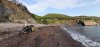
1. All beaches aren't created equal.
2. The $#@&**## traction control defaults to nanny mode.
3. A worn Shinko 705 doesn't provide near as much traction as a good Bridgestone AX41.
4. Good samaritains are all over the world. Were it not for one this morning, I'd probably still be on that beach...
Ha!! English: Barbecue. . . . Irish: Barbeque. Who would have thunk?
AZMike
Well-Known Member
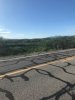
I made a run to the border. Left Tucson to Nogales this morning the back way. I have lived in southern Arizona for 53 years and I have never seen this place so green. If it rains today (which it will) we will break a 58 year old record for rainfall. 155 beautiful miles on the S 10. Love this bike, only had it a few weeks and put 450 miles on her. No iron butt stuff but I still run a business every week. The first pic is looking into Mexico. Crappy pics sorry but I don't stop much.
 n
n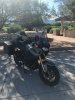
nUnfortunately, extra rain/green vegetation now means greater fuel load and fire risk when it dries out, along with associated erosion. I hear HW 60 is closed between Superior and Globe due to major washouts after recent fires there. They need ~300 dump truck loads to repair. Historic Apache Trail may never be repaired east of Fish Creek.I made a run to the border. Left Tucson to Nogales this morning the back way. I have lived in southern Arizona for 53 years and I have never seen this place so green. If it rains today (which it will) we will break a 58 year old record for rainfall. 155 beautiful miles on the S 10. Love this bike, only had it a few weeks and put 450 miles on her. No iron butt stuff but I still run a business every week. The first pic is looking into Mexico. Crappy pics sorry but I don't stop much.
View attachment 83487nView attachment 83488
Sent from my SM-N950U using Tapatalk
AZMike
Well-Known Member
Yes last year was so bad, no rain at all and this year it won't stop. I love that road from Superior to Globe Best gas mileage I ever got on my Goldwing was on that 12 percent grade.
Best gas mileage I ever got on my Goldwing was on that 12 percent grade.