Route Suggestions: Portland Oregon to Glacier National Park, MT.

Mtbjay

In love with two-wheeled machines
Joined
Oct 22, 2012
Messages
239
Location
Sherwood, Oregon
Roger that, YZ! I've only been to MT and WY twice in my life. Both times, the grizz were alive and visible. BIG creatures they are.
 

Mtbjay

In love with two-wheeled machines
Joined
Oct 22, 2012
Messages
239
Location
Sherwood, Oregon
Thanks for the tips, boys! It all helped as I crafted my turbo route to G2S.


Portland, Oregon to Glacier National Park

Counter-Clockwise -
  • Day 1: 320mi/7hrs - Full moon Oregon desert ridin' thru Shaniko - Fossil and beyond John Day. What a start!
  • Day 2: 450mi/9hrs - Prairie City to Stanley, ID, to Sula, MT.
  • Day 3: 400mi/8hrs - Sula to Going-to-the-Sun road, Glacier National Park to St Mary and back-round to Kalispell, MT on the Hwy 2.
  • Day 4: 420mi/9hrs - Kalispell, to Paradise, OR via Hwy 12 over Lolo Pass.
  • Day 5: 400mi/8hrs - Paradise, to PDX via Joseph, Grass & Tygh Valleys.


2,000 miles in 4 1/2 days

I wish I had more time, but I'll take what I can get and squeeze the most out of it (my usual M.O.). The new tires and Cardo Q3 will be fun to tryout.


URL: to Overview Map -
https://www.google.com/maps/dir/Sherwood,+OR/Prairie+City,+OR/Sula,+MT/St+Mary,+MT/Kalispell,+MT/Paradise,+OR/Portland,+OR/@44.3888831,-119.4530646,7z/data=!4m84!4m83!1m10!1m1!1s0x54954018a273aa69:0x917e95d40682dbb7!2m2!1d-122.840098!2d45.3565074!3m4!1m2!1d-120.4942094!2d44.9152439!3s0x54bc3ad9b84e767b:0xd50a9ddd43976575!1m5!1m1!1s0x54bafe14999a0453:0x323f154572634beb!2m2!1d-118.7099477!2d44.4632135!1m15!1m1!1s0x53593e3eb7b22927:0xaf7bea4018a3e81d!2m2!1d-113.9817463!2d45.8365869!3m4!1m2!1d-114.0170343!2d47.8045856!3s0x5367a1915386d3d9:0xe2d4f7ede37b0e55!3m4!1m2!1d-113.3863683!2d48.2955255!3s0x53688127bb7694c1:0xffa279606d93d8e4!1m10!1m1!1s0x5368b82e593730e5:0x6a0435f0e8ece02d!2m2!1d-113.4295461!2d48.7438663!3m4!1m2!1d-114.3356491!2d48.3623936!3s0x536642bfaf115f1d:0x15ea47c61ce4a825!1m10!1m1!1s0x536650959ceac247:0xaf1fbdda1d5abb62!2m2!1d-114.3168131!2d48.1919889!3m4!1m2!1d-115.3718038!2d46.3054769!3s0x535f6d6714ab5e8f:0xba4e5dda7f518cd1!1m20!1m1!1s0x54a176b49e23a89d:0x34b5007c91a694fb!2m2!1d-117.219559!2d45.939274!3m4!1m2!1d-119.6336525!2d45.9248897!3s0x54a2ac1627195219:0x3e383cc304075fa7!3m4!1m2!1d-120.9201199!2d45.260769!3s0x54bddccb137930d7:0xf3e25f573c54d715!3m4!1m2!1d-121.3966685!2d45.1899374!3s0x54be0d587598d56f:0xe6a0b294f3e3a573!1m5!1m1!1s0x54950b0b7da97427:0x1c36b9e6f6d18591!2m2!1d-122.6764816!2d45.5230622!3e0
 

Attachments

tomatocity

Active Member
2011 Site Supporter
2012 Site Supporter
2013 Site Supporter
2014 Site Supporter
Joined
Mar 1, 2011
Messages
5,251
Location
Sacramento, CA USA
Can you post the URL of the map?

left click, Bars (Upper Left Menu)
left click, Share or embed map
check, Short URL
ctrl + c (copy)
ctrl + v (paste)

Thanks.
 

Mtbjay

In love with two-wheeled machines
Joined
Oct 22, 2012
Messages
239
Location
Sherwood, Oregon
I got no URL's Tomato, they're all screen-shots at low-res, sorry Tomato!

(I tried to log-in and save the maps with my Google acct., but couldn't see how to do it (I've done it before, I'm sure.) Perhaps I can later...
 

tomatocity

Active Member
2011 Site Supporter
2012 Site Supporter
2013 Site Supporter
2014 Site Supporter
Joined
Mar 1, 2011
Messages
5,251
Location
Sacramento, CA USA
Mtbjay said:
I got no URL's Tomato, they're all screen-shots at low-res, sorry Tomato!

(I tried to log-in and save the maps with my Google acct., but couldn't see how to do it (I've done it before, I'm sure.) Perhaps I can later...
Thanks.

I access the URL (instructions), then Copy the URL, then Paste the URL in an email I send to myself (and anyone else that needs it).

You can Copy the URL and Paste it in the Search part of a new Google page. Press Enter and the map will appear.
 

tomatocity

Active Member
2011 Site Supporter
2012 Site Supporter
2013 Site Supporter
2014 Site Supporter
Joined
Mar 1, 2011
Messages
5,251
Location
Sacramento, CA USA
Joined
Jun 23, 2015
Messages
111
Location
81611
Looks Fun! there is a lot of good riding on that route- good luck!

The visitor center on top of Lolo Pass has a lot of good info on Lewis and Clark, if you're in to that stuff.
Also- you might check ahead to see what sort of road construction is going on G2S... that can put a kink into your timetable.
 

Don in Lodi

Well-Known Member
Founding Member
2012 Site Supporter
2013 Site Supporter
2014 Site Supporter
Joined
Feb 1, 2011
Messages
5,779
Location
Lodi Kalifornia
AspentureRider said:
Looks Fun! there is a lot of good riding on that route- good luck!

The visitor center on top of Lolo Pass has a lot of good info on Lewis and Clark, if you're in to that stuff.
Also- you might check ahead to see what sort of road construction is going on G2S... that can put a kink into your timetable.
G2S was clear two weeks ago. The only construction we found was back here in California.
 

Nev..

New Member
Joined
Jul 6, 2015
Messages
17
Location
Greensborough, Australia
I can't help with any route planning, but I am jealous as hell because in May this year I flew out from Australia to Portland OR, hired a bike and rode a 6000 mile loop, hitting the NPs along the way, Yosemite, Bryce Canyon then up to Glacier NP, , but it was a bit too early in the season and the Going-to-the-Sun road was still closed :'( From there through AB and BC then back south through ID, Mt St Helens and bits of the OR coast before returning the bikes back to Portland.

The only thing I can recommend, is stop at Sonny's Tavern in Washtucna WA, and try the "Famous Chicken and Jo's". Got to be about the best fried chicken I've ever eaten. Be very hungry.
 

Mtbjay

In love with two-wheeled machines
Joined
Oct 22, 2012
Messages
239
Location
Sherwood, Oregon
TRIP SUMMAY & PICS!

(Link to high-res photos on SmugMug photo hosting site: https://jasonb.smugmug.com/organize/GS2FBv1

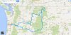
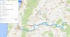
Whew! Made it back in one piece, lads, in spite of record breaking temps. MY riding partner, Brian, and I had a great time on our little trip to Montana. Cousin Mike's handy-work on, "Going-to-the-Sun" road was nothing short of amazing. Especially the "triple arches," on the way to Logan Pass. He's an amazing stone mason - blending nature with civil engineering. The final route was intense riding right from the start. A moonlit ride into the Eastern Oregon desert began the 5-day adventure. The road from Fossil - to Antelope - to Shaniko - was as awesome as I remember; technical, with top-notch road surfacing - it's not to be missed.

After running low on gas, we had to cowboy camp near John Day. [Note: gas stations may say, "Open 24 Hours" on-line - but they require either, A) a Pacific Pride gas card or, B) a call to the station owner who will come down for "a fee," according to the bartender in town.] After a most excellent breakfast at Maria's in Prairie City, we hit the road through the Umatilla Forest and Idaho. Boise was damn hot, but road into the Sawtooth range made up for it in spades. Jade colored mountain streams sliced through rocky ravines amongst the towering ponderosa pines. on our way up, over, and through the forest towards Sula, Montana. We made it just past Gibbonsville, MT, before bedding down for the night at a pristine Montana forest campsite.

The following day we hit the super-highway (I-93) to Missoula and continued north past giant Flathead Lake. It was a hot & dry (and comparatively busy road) up to Kalispell, Montana. Pretty much toast from the heat, we dropped in on Cousin Michael John a bit earlier than anticipated... and downed couple of cold ones. After a 2-hour rest (allowing the would-be traffic in the park to subside) we headed-out for Glacier National Park. The snapshots, undoubtedly, turned out better in the setting sun with texture of the granite peaks clashing against a clear blue sky. Wildfires NE of the visitors center atop Logan Pass in Glacier National Park kept us from crossing the continental divide into St. Mary. "Going-to-the-Sun" road was astounding; not only in it's scenic beauty, but also it's technical prowess. It was cut right into the cliffs on the mountainside and rises seeming into the sky.

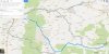
Sunday, plans were modified to avoid a congested return to Missoula. We took Hwy 2 to Sandpoint, Idaho, instead of 12 back to Lolo Pass. I really wanted to see that advised stretch of road, but the alternate route proved a good choice in the end. We made great time that morning riding to Libby, Sandpoint, and finally Coeur d' Alene. It seemed we only had a few moose to keep us company for over 200 miles. The BIG SURPRISE of the trip was 
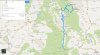
Hwy 129 south, from Asotin (and the Snake River) up to Paradise, Oregon. The rivers have cut such steep & deep gorges and valleys here that the roads constructed must match the elevation gains & drops just to get you there. It was VERY technical road riding, especially at 113 degrees. Hwy 129 traverses straight-up off the Snake River, then continues south into a wicked "Rattlesnake Canyon." This is truly epic terrain for any riding enthusiast - a real sport bikers dreamland. We made Enterprise, Oregon, by early evening and enjoyed immensely a fantastic meal at Terminal Gravity Brewing. Remarkably, we rolled into Joseph after dark and found a spot on the popular Wallowa Lake. The morning light brought us stunning views of Eagle Cap Wilderness with it's towering peaks at 10,000 feet overhead.

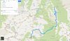
The final day started with even more river valleys and scenic farmland, before a battle with a hot, gusty headwinds around Pendleton. A quick hop back into Washington to see "Stonehenge" had me reminiscing about the movie Spinal Tap. It was pretty cool, but the route into Grass & Tygh Valley's was even better - the Deschutes River cuts a deep gorge here and the road into & out of it is very scenic. A final beer & burger at Portland's own Ecliptic Brewing end-capped the trip.

With 2,100 miles of hard riding in 4.5 days at 100F+, and no offs - I'd say we did pretty good. The Camelbaks were a life-saver, undoubtedly. My fresh set of Conti TKC-70's gave great confidence whenever we hit gravel, but at the cost of ultimate grip on the prevalent, hot & tight, asphalt canyon roads. The front-end tended to wander above 75MPH, but improved some as I adjusted the suspension and either a) the tires flattened a bit from wear or, b) the air pressure came down over the course of the ride. Everything has it's trade-offs.


Thanks for all the advice here before my trip guys. It really helped to be mentally prepared going into such and taxing ride.

Enjoy!


Jason


Mtbjay

In love with two-wheeled machines
Joined
Oct 22, 2012
Messages
239
Location
Sherwood, Oregon
In retrospect, Shrek, I would have taken the 12 to Kalispell, instead of 21 going through Idaho City and Stanley…. The Sawtooths were okay, and there were some good roads, but there was significant delays due to road construction, meanwhile, 12 looks to be more exciting and direct.


Something like this: https://goo.gl/maps/DK2Sm

… is more optimal, while still maintaining the best attributes of the ride. With less than 5 days allotted, this route would allow for more time once we had reached Kalispell, to relax a bit and enjoy the scenery.
 
Top