180 mi Sunday loop in East SF Bay

MrSpock

Member
Joined
Jul 2, 2015
Messages
63
Location
SFBA, CA, USA
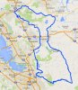
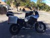
I just came back from a fantastic solo ride in East Bay. About 180 miles of twisties and beautiful terrain around mt Diablo and mt Hamilton. Marsh Creek rd -> Vasco rd -> Mines rd -> San Antonio Valley rd -> Mt Hamilton rd -> Sierra rd -> Felter rd -> Calaveras rd... Lots of fun! Including about 40 mi of lose gravel on San Antonio Valley rd.
 

Attachments

tomatocity

Active Member
2011 Site Supporter
2012 Site Supporter
2013 Site Supporter
2014 Site Supporter
Joined
Mar 1, 2011
Messages
5,251
Location
Sacramento, CA USA
Very nice. Do you have the short URL for this map? So they are still doing gravel on San Antonio Road. We were there about a month ago and they were graveling the top section down to maybe (guessing) the 14 mile marker. How smokey was Mount Diablo?
 

MrSpock

Member
Joined
Jul 2, 2015
Messages
63
Location
SFBA, CA, USA
Yes there is a lot of lose gravel everywhere, few gravel piles, signs everywhere, but no signs of the equipment. So I assume it would take them a while to finish it. There was no smoke anywhere along the route.

Here is the link to some of my maps: https://www.google.com/maps/d/edit?mid=zsqpyBGk3b8c.k73tNuIEqJ0A&usp=sharing All of them, except the Alaska map, are tested and ridden a few times. You can export all, or one-by-one to KML, then import to your GPS. It's what I do with my Zumo 660 anyway.
 
Top