EricV
Riding, farkling, riding...
2011 Site Supporter
2012 Site Supporter
2013 Site Supporter
2014 Site Supporter
So we're not supposed to hug, shake hands or gather in groups right now because of the coronavirus threat. Regardless of what you think about that, nothing stops us from going for a ride. So here is my ride. Feel free to show off your own "Social-Distancing" ride in this thread.
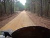
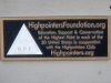
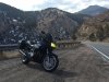
With all the concern, some valid, some over-hyped, and a break from the rain with temps in the low 70's, I thought it was high time I investigated the highest spot in Mississippi. (No, this is not a Ride to Dispensary report. ) I'd seen a blurb about it a few weeks ago when I was looking for a covered bridge for a moto wild card tag game and knew it was fairly close to Iuka, MS. It didn't take much of a Google search to find Woodall Mountain, elevation 807' (246 M) as the highest point in MS. A quick routing gave me some options, all just over an hour to get there from the house and around 70 miles. With a small thread of rain, I opted for the Klim jacket and tossed my rain bibs in the tail bag, just in case.
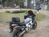
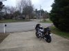
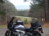
The trusty steed ready to go.
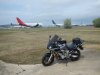
On the way out of the neighborhood I noticed that the aircraft recycler at the Tupelo Regional Airport has gotten in a few new planes. Getting crowded. Usually this is a pre-curser to them getting serious about completely scrapping out the older planes.
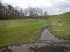
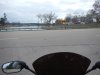
Out at Main street, plenty of people and kids at Ballard City Park. Nice trails, water with geese & ducks, playground, ball courts and fields and a couple museums with the skate park behind.
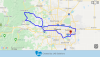
I decided to take the Natchez Trace Parkway on the way up. Very low traffic and much of this leg I had the road to myself. 50 mph speed limit, but just as fast as the highway routes since it traverses from SW to NE and would let me exit at a good spot to pick up local roads and rural highways the rest of the way.
The Trace is starting to green up and a few trees are blooming, (Eastern Red Bud and flowering pear and cherry trees right now).
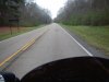
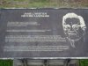
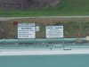
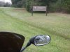
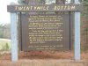
Wandering up the Trace I spotted an overlook sign. Now, this is Northern MS, so the term "overlook" usually results in a not very impressive viewpoint. I grew up in the PacNorWest and lived in Sothern Utah for the last decade before coming to MS. Overlooks there meant epic spots with panoramic views spanning great distances. Here is Twenty Mile Overlook on the Natchez Trace Parkway...
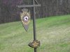
And the money shot...
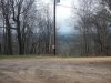
Well, ok you can see for a ways, in this narrow gap in the trees. The sign really tells volumes of what fun traveling in this area was back in the day.
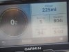
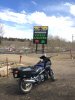
Naturally, since I'm heading for the highest point in MS, I needed to check the GPS to give me some perspective. (The max speed is from the previous owner of the GPS...)
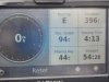
It was going to be a brutal climb to get that additional 411'. Not.
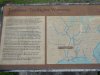
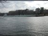
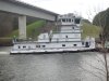
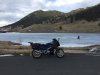
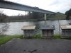
So back on the Trace heading NE I go. As I cross over the Tennessee–Tombigbee Waterway, known as the Tenn-Tom to the locals, I spot a tug with barges. Not something you always get a peek at when crossing over the Tenn-Tom, so I pulled in to the convenient wayside area right over the bridge. I know it has a walking path out to the river and with the slow speed of the barges I could get a picture or two of the tug and barges.
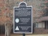
Here is the veiw point at the water's edge that has some interpretive signs.
Continued in next post.
With all the concern, some valid, some over-hyped, and a break from the rain with temps in the low 70's, I thought it was high time I investigated the highest spot in Mississippi. (No, this is not a Ride to Dispensary report.
) I'd seen a blurb about it a few weeks ago when I was looking for a covered bridge for a moto wild card tag game and knew it was fairly close to Iuka, MS. It didn't take much of a Google search to find Woodall Mountain, elevation 807' (246 M) as the highest point in MS. A quick routing gave me some options, all just over an hour to get there from the house and around 70 miles. With a small thread of rain, I opted for the Klim jacket and tossed my rain bibs in the tail bag, just in case.The trusty steed ready to go.
On the way out of the neighborhood I noticed that the aircraft recycler at the Tupelo Regional Airport has gotten in a few new planes. Getting crowded. Usually this is a pre-curser to them getting serious about completely scrapping out the older planes.
Out at Main street, plenty of people and kids at Ballard City Park. Nice trails, water with geese & ducks, playground, ball courts and fields and a couple museums with the skate park behind.
I decided to take the Natchez Trace Parkway on the way up. Very low traffic and much of this leg I had the road to myself. 50 mph speed limit, but just as fast as the highway routes since it traverses from SW to NE and would let me exit at a good spot to pick up local roads and rural highways the rest of the way.
The Trace is starting to green up and a few trees are blooming, (Eastern Red Bud and flowering pear and cherry trees right now).
Wandering up the Trace I spotted an overlook sign. Now, this is Northern MS, so the term "overlook" usually results in a not very impressive viewpoint. I grew up in the PacNorWest and lived in Sothern Utah for the last decade before coming to MS. Overlooks there meant epic spots with panoramic views spanning great distances. Here is Twenty Mile Overlook on the Natchez Trace Parkway...
And the money shot...
Well, ok you can see for a ways, in this narrow gap in the trees. The sign really tells volumes of what fun traveling in this area was back in the day.
Naturally, since I'm heading for the highest point in MS, I needed to check the GPS to give me some perspective. (The max speed is from the previous owner of the GPS...)
It was going to be a brutal climb to get that additional 411'.
Not.So back on the Trace heading NE I go. As I cross over the Tennessee–Tombigbee Waterway, known as the Tenn-Tom to the locals, I spot a tug with barges. Not something you always get a peek at when crossing over the Tenn-Tom, so I pulled in to the convenient wayside area right over the bridge. I know it has a walking path out to the river and with the slow speed of the barges I could get a picture or two of the tug and barges.
Here is the veiw point at the water's edge that has some interpretive signs.
Continued in next post.
Last edited: