Anyone ridden the MABDR solo?

RCinNC

Well-Known Member
Joined
Aug 30, 2014
Messages
2,865
Location
North Carolina
It's tough finding another compatible rider who can spare the time off to do this ride, so I'm thinking of doing it alone. For those that have ridden it, did you encounter any areas along the way that you'd feel were pretty sketchy if you were solo? I'd probably bypass the water crossings unless they were really low. I've ridden Tub Run Road; how does the rest of the dirt parts of the trail compare to that?
 

Dirt_Dad

Well-Known Member
Founding Member
2011 Site Supporter
2013 Site Supporter
2014 Site Supporter
Joined
Sep 21, 2010
Messages
5,973
Location
Northern Virginia, USA
I've done all the WV section and most of MD. On the day I did ot water crossings were fine heading south. I think they'd be a little more challenging going north. But water level is everything. Overall I'd list WV and MD as insanely easy...depending on water level.

Plan to do PA in a couple of weeks.

P
 

RCinNC

Well-Known Member
Joined
Aug 30, 2014
Messages
2,865
Location
North Carolina
Thanks Dirt Dad. I'll be going south to north when I do it. I figured I'd be pretty conservative when it came to the water crossings: it's a long walk if the bike goes down and I either can't recover it or can't get it running again.

I used to live and work in the area of PA that the MABDR passes through. The leaves are already starting to change up there, so you should be in for a nice ride.
 

BaldKnob

Well-Known Member
Joined
Aug 11, 2012
Messages
776
Location
SENC
I just rode the Pennsylvania sections (Little Pine SP to MD border) a couple weeks ago solo. Zero water crossings and mostly hardpack gravel. The only sketchy area was near State College, in the Poe Paddy SP... kinda steep and super rocky. I wouldn’t want to be riding it when wet. If going S to N, you’ll be headed downhill and should be easier. Of all the BDRs, MidAtlantic is the least challenging from what I’ve read. Making a wrong turn and getting lost or finding primitive camping will be your biggest concerns. Go for it.
 

Dirt_Dad

Well-Known Member
Founding Member
2011 Site Supporter
2013 Site Supporter
2014 Site Supporter
Joined
Sep 21, 2010
Messages
5,973
Location
Northern Virginia, USA
Thanks Dirt Dad. I'll be going south to north when I do it. I figured I'd be pretty conservative when it came to the water crossings: it's a long walk if the bike goes down and I either can't recover it or can't get it running again.
If I remember correctly the water crossings were in VA just north of Rt 33. If they are low, should not be much of any thing. My experienced buddy turned around back in May because the area felt too sketchy to him. There are 3 or 4 crossings within a few miles of each other. I believe those are said to be the only crossings on the entire route.
 

RCinNC

Well-Known Member
Joined
Aug 30, 2014
Messages
2,865
Location
North Carolina
When I was preparing some maps that would be compatible with my Garmin Nuvi, I found 10 water crossings in three different sections of Section 3. I mapped bypasses for them and included them as alternate routes in the map overlay. I imagine that some of them might even be dry, depending on the amount of rainfall. When I was up on Tub Run Rd last month, even it had some water filled low areas that turned them into water crossings, but they weren't bad. I've seen some Youtube videos of the MABDR, and it looked like some of the water crossings could get pretty gnarly depending on weather.

I'd heard that part of the Poe Paddy section was pretty rough, but wasn't sure which part. Is it the part that goes east after leaving the Penn's View Overlook? The part with the arrow is what I'm referring to:


I have my route set up to go up to Penn's Overlook and then turn around and go back down, if the part marked with the arrow is too sketchy.
 

BaldKnob

Well-Known Member
Joined
Aug 11, 2012
Messages
776
Location
SENC
Your pin looks like it’s in the right spot. Hard to estimate but it might be less than 2 miles of rocky terrain before the road merges into the Park.
 

s.ga.rider

Well-Known Member
Joined
Dec 23, 2019
Messages
272
Location
South Georgia
I didn't see anything that would have concerned me from going alone besides no cell service on a lot of the trail and it is kind of desolate in places.
 

Dirt_Dad

Well-Known Member
Founding Member
2011 Site Supporter
2013 Site Supporter
2014 Site Supporter
Joined
Sep 21, 2010
Messages
5,973
Location
Northern Virginia, USA
When do you plan to ride the mabdr ...
Started a solo ride this morning. Doing the PA section this trip. Completed sections 6 and 7 today.
Great so far.

20200916_110707.jpg

Be aware, the rocky section is 33 to 35 miles south of the end point of section 7. Anyone considering it should be comfortable with needing to pick a line through unavoidable rocks. It is not for a Tenere rider who is slightly comfortable riding off pavement. You need to be very comfortable handling a big bike in rough stuff. Very doable, but I was glad to be on my little bike and not the Tenere.

The rocky part
20200916_140322.jpg

More like a small snippet of the rocky parts.
 

Dirt_Dad

Well-Known Member
Founding Member
2011 Site Supporter
2013 Site Supporter
2014 Site Supporter
Joined
Sep 21, 2010
Messages
5,973
Location
Northern Virginia, USA
Honestly, best I can do on the 690 is tolerate it. I don't find any joy in rock crawling. Just not my thing.
20200916_140412.jpg

Suggest considering going to just the south side of where that crap starts. Some of the best vistas seen in PA so far were just a few miles south of that rocky crap.

20200916_134818.jpg
 

Dirt_Dad

Well-Known Member
Founding Member
2011 Site Supporter
2013 Site Supporter
2014 Site Supporter
Joined
Sep 21, 2010
Messages
5,973
Location
Northern Virginia, USA
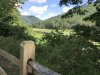
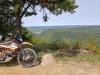
Did section 8 above Rt 192 today... outstanding! I'll get below 192 on the way home tomorrow. What I saw of 8 was my favorite part of everything I've done on the BDR so far.

Fun whoops, amazing woods sections, great views.
20200917_105818.jpg

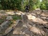
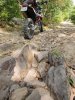
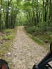
According to my GPS, at 58 to 60 miles south of the end of section 8, there is a stony section. No where near as challenging as the rocky section i mentioned yesterday, but still not as carefree as everywhere else. I probably did no more than 20 mph here, and I heard a lot of rocks pinging off the skid plate. Not an overly difficult section, but skid plate highly recommended.
20200917_095055.jpg

At 23 miles south of the end of 8, the sign said between 20 and 30 September expect up to 1 hour delays due to construction.

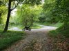
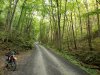
Section 9 is mostly lovely scenery. It got a little sketchy with several miles of freshly graded road (like done today). Actually had to ride it fairly slow.

20200917_144418.jpg
There are a couple of missed sections i need to hit on the way home, but I've pretty much done everything from Rt33 in Virginia to the end. I can say, what I've seen, in my opinion , the overwhelming majority of the MABDR is Tenere friendly for riders with basic dirt skills, and a real gem of a ride. Hats off to BDR organizers. They did a truly great job stringing together dirt roads and awesome paved sections in Pennsylvania.

Looking forward to seeing what they've done south of Rt 33.
 

s.ga.rider

Well-Known Member
Joined
Dec 23, 2019
Messages
272
Location
South Georgia
I did the rock section on the s10 and agree with the above comments. I made it through fairly easy on the s10 with no issues besides me being out of shape. Definitely a work out.
 
Top